Polyrrinia or Polyrrhenia, the Town and the Acropolis
Polyrrinia or Polyrrhenia
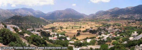
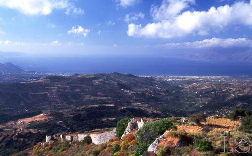
Polyrrinia or Polyrrhenia is a small village in the Kissamos area, in the northwest of Chania Prefecture. Polyrrinia is set on a hill dominating the surrounding area, 10 minutes’ drive from Kissamos (Kastelli).
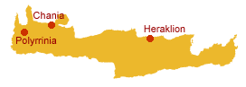
Table of Contents
How to get to Polyrrinia
From Kissamos to Polyrrinia: take the road which starts after Kissamos and climbs to Polyrrinia, 7 kilometres away. You can also take a taxi or the KTEL intercity bus.
From Chania to Polyrrinia: first drive west to Kissamos (43 kilometres) and then another 7 kilometres to Polyrrinia. The whole trip is about 1 hour’s drive.
Polyrrinia on the map
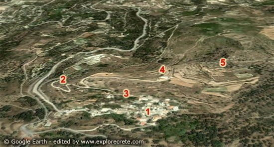
Νο. 1 – village of Polyrrinia | Νο. 2 – road to the Acropolis of Polyrrinia| Νο. 3 – road to the archaeological site through the village (recommended) | Νο. 4 – church at the beginning of the archaeological site | Νο. 5 – Ancient Acropolis of Polyrrinia
Visit Polyrrinia
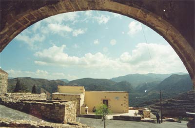
The village of Polyrrinia is worth visiting both for its traditional atmosphere and for the ruins of the acropolis of the same name, at an altitude of 418 metres.
The surviving ruins date from the Hellenistic, Roman and Byzantine periods.
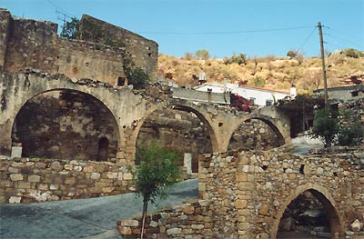
In the village of Polyrrinia you can admire the Roman aqueduct, the old houses and the Venetian archways opposite the wonderfully restored community building.
History of Ancient Polyrrinia
Ancient Polyrrinia was built in around 1100 BC by Achaean and Laconian colonists, although the area had been inhabited for far longer. The city was built in a horseshoe shape on a hilltop about 420 m high.
The history of Polyrrinia begins in the Late Minoan period and runs to Roman times, which is when most of the surviving finds date from.
Ancient authors refer to the city from Hellenistic times as Polyrrinia or Polyrrhenion (Pliny). Its political system is though to have been the same as that of Sparta, i.e. aristocratic, with many organisational and administrative elements borrowed from the Laconians. Polyrrinia became a powerful city with two harbours, one at Falassarna and one at Kissamos.
The etymology of the name Polyrrinia (Πολυρρήνια in Greek) indicates the main occupation of its inhabitants: it is derived from the words poly (many) and rinia (sheep, ρήνια in Greek). Ioannis Stamatakis says that “polyrrin” means “rich in lambs”.
However, the symbol of the city, stamped on its coins, was a bull’s head, known as a bucranium. The reverse of the coin depicted Zeus Cretagenes, the “Cretan-born Zeus”.
King Agamemnon at Polyrrinia
According to tradition, King Agamemnon anchored near Polyrrinia, in the Nopigia area, to offer a sacrifice to the gods on his return from the victorious Trojan War. But before the sacrifice could be completed, he saw his ships being set alight by the rebelling captives and had to leave in a hurry. Ever since, blood sacrifices left unfinished for some reason were known as “Cretan Sacrifices“, and there was even a phrase in ancient Greek meaning “to perform a Cretan Sacrifice”.
Byzantine Polyrrinia
The city of Polyrrinia was strongly fortified in Byzantine times. To this period dates a place of worship uncovered during Theophanides’s 1942-44 excavation.
Houses carved into the rock and the remains of an aqueduct have been found at Polyrrinia, along with a Hellenistic guard tower preserved in a square of the city. Historians tells us that the cemetery extended northwest of the Acropolis.
The Temple of Artemis Dictynna at Polyrrinia
On the Acropolis of Polyrrinia stood the Temple of Artemis Dictynna, where the small church of Agioi Pateres (the Holy Fathers) is today. It was built in 1894 using material from the ancient temple.
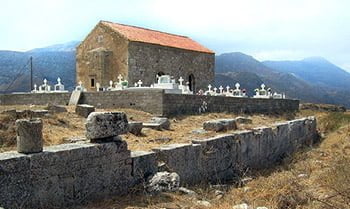
You can see this for yourself if you visit the Acropolis, as ancient inscriptions are set into the church walls, and part of the ancient altar has been used in the Christian one.
Polyrrinia, the Roman ally
Polyrrinia played an important part in Roman times, mainly due to its strategic decision to ally itself with the conquerors and assume a leading role in the area, defeating even its oldest enemy, ancient Cydonia, now Chania.
From this period survive the Roman aqueducts with their overflow cisterns, and fountains set in places of worship. The water pipes run under the hill on which the city stands, and are combined with a network of stairs and underground exits which must also have formed part of the defences.
The semi-circular tower in the walls at the entrance to the village is thought to have been another combined defensive and hydraulic work. The tower has been badly damaged, and its facing stones were used as building materials for the local primary school in the early 20th century.
How to get to ancient Polyrinia
You can get to the Acropolis, i.e. Ancient Polyrrinia, either on foot through the village (Road No. 3 on the map above), or by car along the dirt track at the entrance to the village on the left (Road No. 2).
If you take the second route (Νο. 2), you can leave your car in the small car park of the Akropolis Taverna, owned by Yannis Sfakianakis.
Bear in mind that it’s quite a steep climb to the ancient acropolis. It’s no problem for young, healthy people, but elderly people or those with health problems may find it difficult to climb, especially in the summer heat.
Try to go early in the morning or late in the afternoon when the light is gentler and the sun not so hot.
Read more:
- Polyrrinia gorge or Sirikari gorge, hiking from Sirikari to Polyrrinia
© explorecrete.com All Rights Reserved. Reproduction or copying without permission is prohibited.